EXPLOITS SNOWMOBILE
I have an iPhone and Android app that is available now with trails all across Newfoundland and Labrador. You can get it here
Please email me or send a message to me on facebook
if you need track files for a gps that isn't listed.
If you have track files you would like to make available to others, please email the files to snowtrailsnl@exploits-snowmobile.com
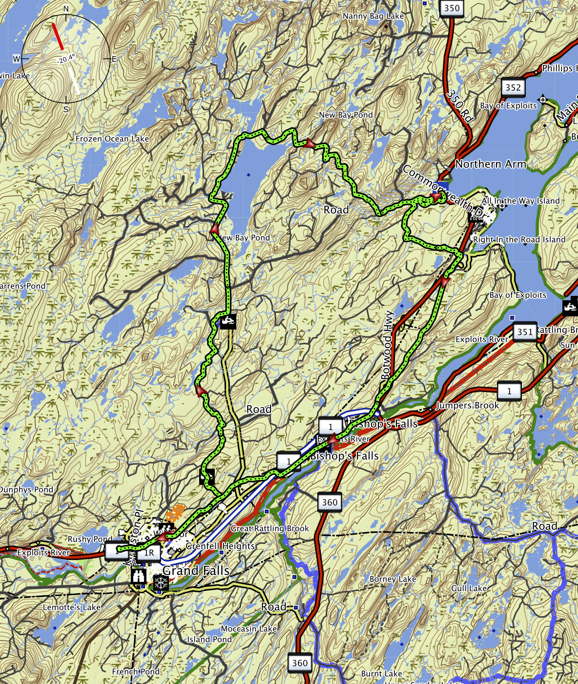
The overview maps are printable
I am in the process of organizing and posting new trails on the website and in the app, I am still learning the new map system and spending most of my time getting the app trails in shape, Updates will be ongoing
| Western Region | Northern Region | Eastern |
| Click Description for overview
picture of track |
Garmin GPX |
Magellan |
Magellan |
Magellan |
Lowrance |
Distance |
| IBEX Fuels to Riverfront Chalets | Garmin | Mapsend 4 |
Explorist |
Meridian |
Lowrance USR4 |
21.3 KM |
| Riverfront Chalets to Badger | Garmin | Mapsend 4 |
Explorist |
Meridian |
Lowrance USR4 |
4.2 KM |
| Badger to Skull Pond | Garmin | 17.7 KM | ||||
| Skull Pond to Millertown Jct | Garmin | 8.0 KM | ||||
| Millertown Jct to Millertown | Garmin | 23.5 KM | ||||
| Millertown to Buchans | Garmin | 32.0 KM | ||||
| Skull Pond to Crooked Lake via Powderhorn | Garmin | 28.6 KM | ||||
| Powderhorn to Rocky Brook Warm up shelter | Garmin | 16.2 KM | ||||
| Rocky Brook Warmup Shelter to Hodges Hill and 9 mile Bog | Garmin | 31.8 KM | ||||
| MaryAnne Brook to Crooked Lake | Garmin | |||||
| Trail Bed to New Bay Lake Causeway | Garmin | 30.4 KM | ||||
| New Bay Lake Causeway to Northern Arm | Garmin | 19.9 KM | ||||
| NewBay Road to 9 Mile Bog via Rowsell's Road | Garmin | 14.3 KM | ||||
| 9 Mile Bog (Use at own risk) there are some markers | Garmin | 9.9 KM | ||||
| IBEX Fuels Grand Falls-Windsor to Bishop's Falls | Garmin | 12.9 KM | ||||
| Bishop's Falls to Botwood Ultramar | Garmin | 16.1 KM | ||||
| Bishops Falls to Sunday Pond Road Through Pine Camps | Garmin | 16.5 KM | ||||
| Sunday Pond Road to King's Castle Intersection | Garmin | 32.5 KM | ||||
| Kings Castle Intersection to Mt. Peyton | Garmin | 18.6 KM | ||||
| Jumpers Brook Rd to Kings Castle Intersection | Garmin | 19.0 KM | ||||
| Mt Peyton to Lewisporte Jct to Bishops Falls | Garmin | 62.9 KM | ||||
| Newbay
trail to Botwood and return through Bishops Falls (Botwood Loop) |
Garmin | Mapsend 4 | 85.7 KM |
| Central Area 6 Page overview map (All Trails groomed by Exploits Trailnet) and some that are not groomed | Download |
| Track bed to Newbay trail shortcut (If Frozen) | Garmin | 1.7 KM |
|||
| Peter's River Bypass (for when not frozen) | Garmin | 3.0 KM |
|||
| Hodges Hill trail to track bed via Lou Bushy's Road | Garmin | 12.4 KM |
|||
| Botwood Ultramar to Northern Arm Trail (Not groomed) | Garmin | 10.1 KM |
|||
| Track Bed in Bishop's Falls to Tim Horton's and Irving Gas Station on TCH | Garmin | 1.1 KM |
|||
| Groomed trail to the Summit of Hodges Hill | Garmin | 5.6 KM |
|||
| Loop Road (Rowsell's Brook around to NewBay Causeway) Coming soon |